I audited Togo’s two open data portals: opendata.gouv.tg (the general-purpose data portal) and geodata.gouv.tg (the cartographic geoportal), based solely on the public signals these portals expose. All 1,550 datasets were inspected one by one, and the portals were compared against ten peer countries — France, the United Kingdom, Kenya, Ghana, Côte d’Ivoire, Senegal, Rwanda, Burkina Faso, Nigeria, Benin — as well as the international commitments most open governments have signed.
This post summarises the findings. The full report, the Python scripts that reproduce it, and all raw data are public: github.com/gausoft/togo-opendata-audit.
The intent is constructive. The diagnosis is severe, but the fixes are within reach — no budget, no hiring, no software to buy. On paper, Togo has a complete open data infrastructure: a general-purpose portal powered by udata (the same free software as data.gouv.fr) and a geoportal backed by an institutional GeoServer. The tools are there, the standards that could make them credible have existed for ten years. What had not been documented publicly with numbers is the gap between appearance and substance. That’s what this work does.
Five numbers to frame the diagnosis
- 18 months since launch (first dataset published on 22 November 2024) — and 99.7% of records have not been touched since the first quarter of 2025. The portal is a frozen snapshot, not a living feed.
- 1,230 datasets dumped in two months (December 2024 + January 2025), then publication collapses: 312 in February–March 2025, and only 5 datasets between April 2025 and May 2026. The curve has the shape of a project shipped rather than that of a service operated.
- None of the governance features the software ships with are turned on: not the public per-ministry quality score page, not the usage analytics, not the channel that would let third-party tools (European, African, academic) automatically index the Togolese catalogue. These features exist by default in the software — leaving them off is a deliberate act.
- The Ministry of Defence (18 datasets) and the Ministry of Security (7 datasets) publish 100% empty files — only the column dictionary, with zero rows of data. The Ministry of the Digital Economy, whose core mandate this should be, sits at 87% empty files.
- The geoportal exposes a single map layer through the open WMS standard, in a workspace named
prise_freely_available. The official contact card for this Togolese public service has been left on GeoServer’s default values: “Claudius Ptolomaeus, Roman Empire, Alexandria.” And Togo is the only national portal of the eleven compared that has signed neither the Open Data Charter nor the Open Government Partnership.
None of these findings is due to a lack of technical means. udata and GeoServer are free and open-source, and the same software stack powers a French portal that publishes 50× more datasets and updates them daily. Viewed from outside, the gap is therefore not technological.
A timeline that says it all
The publication curve, reconstructed from the creation dates of each of the 1,550 datasets (public information provided by the portal itself), tells the story of a project delivered rather than a service operated:
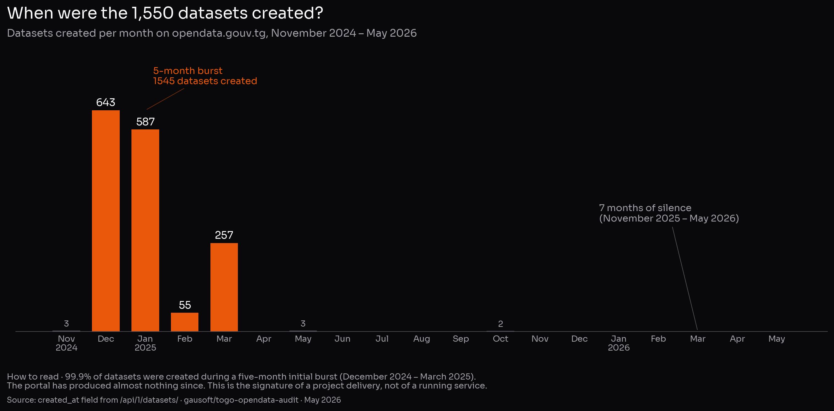
80% of the portal was published in the first two months (1,230 datasets across December 2024 + January 2025), in what looks like a massive initial dump — most likely the migration of a pre-existing data stock. The 13 months that followed account for 5 datasets. As of this audit, no publication has been recorded for seven consecutive months.
The same phenomenon shows up if we look not at creation dates but at the last-modified dates of the records: 99.7% of them have not moved in over 12 months. A wall, not a distribution.

This timeline is what separates an open data portal from an open data showcase. Public data is, by nature, a flow: monthly statistics, public procurement, budget execution, sectoral indicators. A portal frozen for a year is rarely a portal in growing pains; much more typically, it is a portal whose production cycle has been interrupted — or one whose publications, if they continue internally, no longer reach the public surface.
Who uses this portal? We don’t know
The official figures published by the portal show zero views, zero downloads, zero reuses. These zeroes do not mean there were no visitors — there have been some, and I myself downloaded a dozen datasets without any of those downloads showing up in any counter.
What these zeroes indicate is that the public counters are not being fed. The software offers several native ways to display visits and downloads; none seems to be active on the public side. It is entirely possible that the administration has, internally, server logs or a private analytics tool — but that information, if it exists, is neither published nor shared with data producers.
That, in its own way, is more concerning than a measured low volume: nothing in what is publicly exposed makes it possible to know how many citizens, journalists, researchers, or businesses are consulting these data. Without that shared signal, it is hard to prioritise which datasets to improve, or to defend the service against a supervisor asking what it is for. An open data portal without visible audience measurement is a public service whose dashboard is not shared.
The official usage figures are therefore treated, in the rest of this audit, as non-significant — what is documented is not the absence of a public, but the absence of public instrumentation.
How the audit was conducted
Everything rests on public information, accessible to anyone with a browser:
- The metadata for the 1,550 datasets was retrieved through the portal’s public API (the same one used by mapping tools and data journalists).
- The actual file contents were sampled dataset by dataset: we download the first kilobytes of each resource to verify what it really contains, rather than trusting the title.
- The geoportal was queried via the standard cartographic protocols (those any GIS application uses).
- The eleven peer countries were compared on their public counters and their declared international commitments.
The code, raw data, and per-file classifications are public on GitHub. Everything is reproducible in 15 minutes.
The “blueprint instead of data” anti-pattern
This is the most surprising finding of the audit. Of the 1,550 datasets, 102 (6.6%) do not contain the announced data — they contain the schema of that data.
Concretely: a file titled “geolocated coordinates of telecom towers in Togo”, which a researcher or journalist downloads expecting a list of antennas, opens onto fifty-odd lines of the form “column 1: region name; column 2: prefecture name; column 3: municipality…” — and zero rows of antennas. For a public service, that is the equivalent of publishing the questions of a survey instead of the answers collected.
The breakdown by ministry is highly uneven
The pattern is not uniformly distributed — it is extraordinarily concentrated on certain administrations:
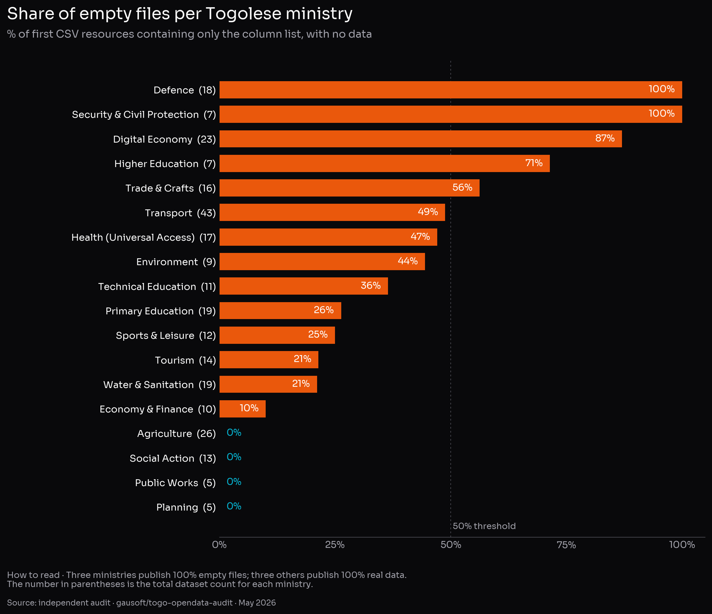
Reading: INSEED, the Ministry of Agriculture, and the Ministry of Public Works prove that clean publication is possible in the Togolese context. The diagnosis is therefore not “the portal is empty” but “some administrations published their blueprints instead of their data.”
The geoportal: Claudius Ptolomaeus, Chief Geographer
The Togolese geoportal (geodata.gouv.tg) runs on GeoServer, the industry-standard free software for cartography — the same one used by France’s IGN and by NASA. And here is the most visible finding of the entire audit: when you query the service’s identity card through the standard endpoint that any GIS tool (QGIS, ArcGIS) uses to connect, here, word for word, are the contact details of the “official contact” of the Togolese geoportal:
Contact person: Claudius Ptolomaeus
Position: Chief Geographer
Organisation: OSGeo
Address: Alexandria, Egypt, Roman Empire
Email: claudius.ptolomaeus@mercury.olympus.gov
Claudius Ptolemy is the 2nd-century AD Roman geographer. These details are the example record that ships by default with GeoServer. The instance was installed, plugged into the internet, declared as a public service — and the example record has, to date, not been replaced with the ministry’s actual contact.
In the same vein, the geoportal exposes a single base map through the standard connection. Several other cartographic protocols any GIS tool expects (vector download, metadata catalogue, modern API) are either disabled or locked behind an undocumented password. The result: a visually rich web application, but practically unusable for anyone who would want to build a service on top of it.
An open data portal invisible to others
The standard format that lets one open data portal be automatically indexed by others — European, international, or simply Google Dataset Search — is called DCAT-AP. It is what makes a dataset published on data.gouv.fr appear within hours on data.europa.eu. The software Togo uses exposes this feed natively; it just has to be switched on. On opendata.gouv.tg, it is not. in reality, after a direct API check, a partial generic DCAT export is already online but broken: only ~200 of the 1,550 datasets appear (the internal pagination declares totalItems = 2), the standard /catalog.xml URL that harvesters look for returns 404 — the feed is only exposed on an internal route, /api/1/site/catalog.xml, that nothing queries by default — and the European DCAT-AP profile is not declared. As a result: no external tool can automatically discover Togolese datasets. The activation cost is zero. The fix amounts to three documented udata configuration adjustments.
Regional comparison
| Country | Portal | Software | Datasets | Last update | OGP | ODC |
|---|---|---|---|---|---|---|
| France | data.gouv.fr | udata | 74,000 | daily | ✅ | ✅ |
| United Kingdom | data.gov.uk | CKAN | ~30,000 | active | ✅ | ✅ |
| Kenya | opendata.go.ke | ArcGIS Hub | n/a | being relaunched | ✅ | ❌ |
| Ghana | data.gov.gh | CKAN | 271 / 912 | n/a | ✅ | ❌ |
| Côte d’Ivoire | data.gouv.ci | proprietary | 177 | n/a | ✅ | ❌ |
| Senegal | distributed ecosystem | various | n/a | varies | ✅ | ❌ |
| Burkina Faso | data.gov.bf | CKAN | 200+ | irregular | ✅ | ❌ |
| Nigeria | data.gov.ng | CKAN | n/a | sectoral | ✅ | ❌ |
| Benin | data.gouv.bj | CKAN | inaccessible | n/a | ✅ | ❌ |
| Togo | opendata.gouv.tg | udata | 1,550 | frozen | ❌ | ❌ |
Three readings:
- Togo is ~50× smaller than France on identical software. Viewed from outside, the gap appears organisational rather than technical.
- The Togolese portal lists 5–10× more datasets than Ghana’s or Côte d’Ivoire’s, but those two countries are members of the Open Government Partnership and Togo is not. In other words, the number of records published is not, in itself, a measure of open data maturity: a smaller but actively governed portal is worth more than a bulky deposit left without stewardship.
- Of the eleven portals compared, Togo is the only one signed up to neither the OGP nor the ODC.
Ten recommendations, sorted by effort
None of the recommendations below was invented for this audit. They all rest on existing public references: the Open Data Charter principles, the W3C DCAT v3 interoperability standard and its European profile DCAT-AP 3.0, the European High-Value Datasets regulation (EU 2023/138), the FAIR principles, the Open Definition 2.1, the EU Open Data Maturity Assessment methodology used by the 27 member states, and the academic literature on metadata quality (Neumaier et al., ACM JDIQ 2016; Frictionless Data, 2020). Each recommendation indicates in parentheses what it relies on.
Within days
Activate the channel that makes the portal visible to other portals (the DCAT-AP format, shipped by default with the software).Fix the DCAT-AP feed that makes the portal visible to other portals: repair the Hydra pagination (which only exposes around 200 datasets out of 1,550), publish the standard/catalog.xmlURL at the portal root (currently a 404, the feed only exists at/api/1/site/catalog.xml), and declare the European DCAT-AP profile. Immediate effect: automatic indexing by European and international directories. (Standard: DCAT-AP 3.0, W3C recommendation August 2024.)- Activate the public per-ministry quality score page (also shipped by default). Effect: a free accountability mechanism — every administration sees, and the public sees, who publishes cleanly. (Native udata feature; “Open by Default” principle of the Open Data Charter.)
- Replace the GeoServer example record with the Ministry of the Digital Economy’s contact details. Ten minutes of configuration. (Metadata required by ISO 19115 for any geographic record.)
Within weeks
- Rework the 102 “questions instead of answers” datasets — either remove them or republish them with the actual file. These cases are concentrated on four or five ministries: the list is in the report. (Anti-pattern documented by Frictionless Data 2020 and Neumaier et al., ACM JDIQ 2016; violates the FAIR R1 principle “data are richly described” — here metadata replaces the data.)
- Publicly document how to connect to the geoportal, or align it with the standards already used by the main portal. (OGC WMS/WFS/CSW standards; FAIR A1 principle “data are retrievable by their identifier using a standardized communications protocol.”)
- Open the public download of cartographic layers already declared open data. (Consistency with the dataset’s declared licence; Open Definition 2.1: open data must be retrievable “without restriction.”)
Within the quarter
- Publish an update frequency policy: for each theme (health, transport, economy…), set the minimum update cadence and make it public. (“Timely and Comprehensive” principle of the Open Data Charter; the European HVD regulation EU 2023/138 imposes minimum cadences by theme; Neumaier et al. 2016 considers a dataset stale beyond twice its declared cadence.)
- Set up an automated pre-publication check that rejects empty or near-empty files. A few-line script would have prevented the 100 cases identified here — if such a check already exists internally, it appears, viewed from outside, not to have been triggered on these datasets. (Standard tools: Frictionless Data validator; Validata, already used by data.gouv.fr at pre-publication.)
- Hook up public audience measurement for the portal. As of today, nothing in what is publicly exposed makes it possible to know how many citizens consult these data — prioritising quality efforts without that shared signal is guesswork, even if the administration holds server logs internally. (The EU Open Data Maturity Assessment, which ranks the 27 member states, makes usage measurement one of the four pillars of its score — alongside policy, portal, and quality.)
Within the year
- Initiate accession to the Open Government Partnership and sign the Open Data Charter. Two free processes, with no financial requirement. Of the 10 peer countries in this audit, 8 are already OGP members — every one of them except Togo and Rwanda. Within ECOWAS, Benin, Burkina Faso, Cabo Verde, Côte d’Ivoire, Ghana, Liberia, Nigeria, Senegal, and Sierra Leone have all joined — 9 states out of 15. Staying out means diplomatic isolation on a terrain where West Africa’s ecosystem has already converged. Togo even passed the OGP Values Check assessment but never formalised membership, despite a public invitation in 2018.
Why this matters: governance, not tools
It is tempting, reading this audit, to reduce it to a list of technical knobs to tick. That would miss the point. An open data portal is not an end in itself — it is a governance instrument. Its purpose is to produce three concrete effects, documented by twenty years of literature and by the experience of countries that have made it work:
- Accountability: enabling the press, researchers, civil society, and Parliament to verify public action against records, rather than against statements.
- Administrative efficiency: breaking down silos between ministries, preventing each from rebuilding data its neighbour already holds, and lowering the cost of producing public statistics.
- Economic development: enabling businesses, startups, and NGOs to build services on top of public data — this is, for example, what spawned in France entire sectors around transport, health, or public-procurement data.
None of these effects kick in at the deployment of a portal. They kick in during its regular operation — that is, the moment a governance framework compels administrations to publish, controls what they publish, and answers public requests when publication lags.
Togo already has a legal framework
Here is the point often overlooked in the public debate: Togo has had, since 2016, a law enshrining access to public information as a right. It is law no. 2016-006 of 30 March 2016 on freedom of access to public information and documentation (official PDF, Audiovisual Council). This text, in line with international standards (Article 19 of the Universal Declaration of Human Rights, International Covenant on Civil and Political Rights), establishes that any person, without having to justify a particular interest, can request communication of documents held by an administration.
A right-to-information law is not equivalent to an open data policy — it operates on a request-response model rather than proactive publication. But it is the missing legal foundation to move open data publication from optional initiative to administrative obligation. Several jurisdictions (France, the UK, Mexico, Brazil) have made this transition by complementing their access law with a decree or directive mandating proactive publication of the most-requested data categories — budgets, public procurement, sectoral statistics, geographic data.
The opendata.gouv.tg portal is, in this logic, the tool that exists ahead of the framework that would make it mandatory — the reverse of the logical order. As long as publication is neither made visibly mandatory, nor publicly measured, nor backed by an accountability mechanism, it remains discretionary — and the timeline detailed above (1,230 datasets in two months then silence) is exactly what a discretionary policy looks like, viewed from outside.
What is at stake internationally
The commitments exist and Togo is exposed to them:
- UN Sustainable Development Goal 16.10: “ensure public access to information and protect fundamental freedoms.” Indicator 16.10.2 specifically measures the effective implementation of access-to-information laws — and Togo is rated on it every year.
- Africa Data Policy Framework adopted by the African Union in 2022, which calls on member states to adopt a national data policy explicitly covering open data.
- Open Government Partnership and Open Data Charter — already mentioned, with signatories representing nearly all of Togo’s regional neighbours.
In each of these frameworks, the evaluation criterion is not “is there a portal” but “are the published data up-to-date, accessible, reliable, and actually used.” An abandoned portal does not drag the score to zero — it drags it negative, because it signals a gap between display and reality.
What real open data governance looks like
Countries that have made the transition share four traits, none of them technological:
- A clearly designated administrative authority responsible for the portal, with a budget, headcount, and written mandate — typically a state digital agency (in France: Etalab and DINUM; in the UK: the Government Digital Service).
- A legal or regulatory obligation of proactive publication weighing on the other administrations, with an enforceable update calendar.
- A transparent measurement and publication mechanism for the indicators: who publishes, who doesn’t, who updates, who fails to respond to citizen requests.
- An institutionalised dialogue with the press, research, civil society, and the private sector — typically the format of the national action plans required by the OGP and the Africa Data Policy Framework.
The technical portal is the easiest piece. Togo already has it. What seems to be missing today, judging by the public signals, is the governance framework that would turn it into a public service in the full sense — meaning a service one keeps operating, and publicly documenting, after the launch ceremony.
To conclude
Togo has real, concrete assets: a free and modern state-grade software stack (udata), an INSEED that demonstrates dataset after dataset that clean publication at scale is possible in the Togolese context, an open licence covering most of the portal, and a legal foundation that has already enshrined the right to information since 2016.
Switching on ten configuration parameters, republishing 100 files, and saying publicly “this is the cadence at which each ministry will update its data, and this is who is accountable for it” would, in one quarter, transform the country’s standing in international rankings. But it is not the technical knobs that will produce the value — they are only an enabling condition. Value will come from the governance that compels, month after month, administrations to feed this portal as they feed their other public-service obligations, and that makes this feeding visible. The rest follows. Without that, even the best portal ends up looking like what this one shows today, viewed from outside: built, launched, and quietly left without public follow-through.
Reproducing the audit, flagging a correction
This audit was conducted in May 2026, independently, on public data only, with free software and fully documented scripts. The full apparatus (scripts, raw data, long report, screenshots) is on GitHub: github.com/gausoft/togo-opendata-audit. Anyone with Python on their machine can re-run the collection and verify the numbers in about fifteen minutes.
- Scripts under MIT licence
- Report, analyses, and raw data under CC-BY 4.0 (the licence declared by the source portal)
Any factual correction is welcome and will be integrated. If an administration wishes to flag an error or a recent update I might have missed, GitHub provides public traceability of amendments: github.com/gausoft/togo-opendata-audit/issues.
Full report (FR/EN), methodology, raw data, and scripts: github.com/gausoft/togo-opendata-audit
Sources
- Audit data — opendata.gouv.tg · geodata.gouv.tg · github.com/gausoft/togo-opendata-audit
- Software & standards — udata · GeoServer · IGN · DCAT v3 · DCAT-AP 3.0 · ISO 19115 · OGC · FAIR · Open Definition 2.1
- International frameworks — EU Open Data Maturity 2024 · HVD EU 2023/138 · OGP · Open Data Charter · SDG 16 / indicator 16.10.2 · Africa Data Policy Framework
- Legal framework — Togo Law 2016-006 · UDHR art. 19 · ICCPR
- Validation & literature — Frictionless Validator · Validata · Neumaier et al. 2016 · Frictionless 2020
- Reference agencies — DINUM · UK GDS · data.europa.eu